A Road Trip To Þingvellir – The Quiet Way, Via Mosfellsdalur
Almost every visitor reaches Þingvellir National Park the same way: as the first stop on the Golden Circle, direct and quick. This route takes the slower road instead, through Mosfellsdalur valley on Route 36, passing two waterfalls that most Golden Circle itineraries skip entirely before arriving at the same national park by a quieter approach.
Þingvellir is the site of the Alþingi, the country’s original parliament, and sits directly on the rift valley between the North American and Eurasian tectonic plates. What this route adds is the approach, a valley of farmland and waterfalls that most people drive straight past.

This article contains links to products and services that I think you will find useful. I may earn a commission on any purchases you make at no cost to you. As an Amazon Associate, I earn from qualifying purchases. Read more HERE
Reykjavík to Þingvellir at a glance
- Starting point: Reykjavík
- Round-trip distance: about 145km
- Drive time: 3 hours driving, excluding stops
- Key roads: Route 1 to Mosfellsbær → Road 36 (Þingvallavegur) → Road 48 (Kjósarskarðsvegur for Þórufoss) → then back to Road 36 to Þingvellir National Park (Þingvallavegur) → 360 (Úlfljótsvatn) → Road 435 (Nesjavallaleið)
- Best season: Year-round; the paths at Þingvellir can be icy in winter
- Highlights: Helgufoss · Þórufoss · Þingvellir National Park · Öxarárfoss
The Route – Stop by Stop
Stop 1 – Helgufoss
Off Þingvallavegur (36), Mosfellsdalur · around 15km from Reykjavík · Allow 30-45 minutes
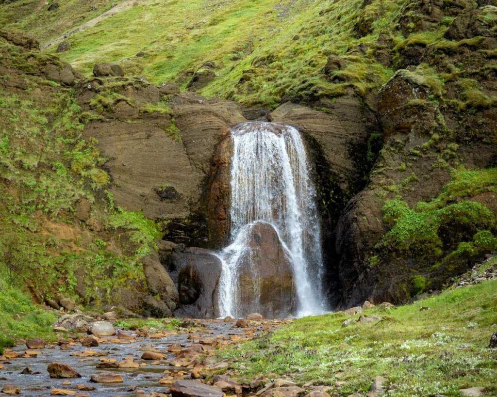
A modest waterfall, around 12 metres high, reached by a short, easy walk from a car park just off the main road. It sits in a sheltered, mossy setting in the Mosfellsdalur valley; the parking area for this waterfall also marks the start of a longer local trail network associated with the writer Halldór Laxness, whose former home in the valley is now a museum.
Stop 2 – Þórufoss
Kjósarskarðsvegur (48), off Þingvallavegur · around 6km from Helgufoss · Allow 20-30 minutes
A wider waterfall on the Laxá í Kjós River, around 18 metres high and broader than it is tall, is framed by dark basalt cliffs. It gained wider recognition after appearing in an episode of Game of Thrones, though the site itself remains quiet, with no facilities beyond a small parking area and a short path to a viewpoint above the falls.

Stop 3 – Þingvellir National Park
Þingvallavegur (36), continuing south · around 15km from Þórufoss · Allow 2-3 hours
A UNESCO World Heritage Site and the location of the Alþingi, founded here in 930, making it one of the world’s oldest surviving parliamentary institutions. The park sits directly on the rift valley between the North American and Eurasian tectonic plates, with a marked path, Almannagjá, running through the gap between them. The visitor centre has parking, toilets and information panels, and the main paths are well maintained, though some sections can be uneven or icy outside summer.

Stop 4 – Öxarárfoss
Within Þingvellir National Park · short walk from the main path · Allow 15-20 minutes
This is a waterfall within the park itself, reached by a short path from the main route through Almannagjá. It’s a natural final stop before heading back towards Reykjavík, and one most visitors reach without any extra driving, since it sits directly alongside the park’s main walking route.

Alternatively, you can drive from the main visitor centre to the lower parking area. This takes you directly into the valley with the waterfall. If you are tight on time, then this is an easy decision.
This is also where the Silfra diving starts. You can snorkel or dive between the plates in crystal clear but freezing water.
Book your Silfra snorkel here
How to Plan Your Visit
Helgufoss and Þórufoss both involve short walks rather than significant hikes, so this route is accessible to most visitors regardless of hiking experience.
Þingvellir itself is the stop that needs the most time; two to three hours is realistic if you want to walk the length of Almannagjá and see Öxarárfoss rather than a quick stop at the main viewpoint.
From Þingvellir you have the option to return along Road 36 or take the longer route around the south shore of Þingvallavatn. This involves taking Road 360 before heading west along Road 435 across a wide lava field covered in moss.
Getting Around
All roads on this route are surfaced, including the turn onto Kjósarskarðsvegur, Road 48 for Þórufoss. Parking at Þingvellir is paid, and the fee also covers a period of time at other paid parking areas within the wider Golden Circle region.
What Else is Nearby
Laxness Museum
The former home of Nobel laureate Halldór Laxness, in Mosfellsdalur near the Helgufoss car park, now a museum of his life and work.
Laugarvatn
Laugarvatn is a small lakeside town further along the Golden Circle route, with a geothermal bakery and hot springs. It is home to Fontana Geothermal Baths and the Caves of Laugarvatn. This is one of the first stops after Þingvellir if you are heading east.
Book your Fontana tickets here
Hvalfjörður, Akranes and Glymur
Our route north of the city via Hvalfjörður sits on the opposite side of Reykjavík and offers a similarly quiet alternative to the Golden Circle if you’re building a longer stay around several of these short trips.

Plan Your Iceland Trip
This overview covers the stops and what to expect, but not turn-by-turn directions, parking locations, or how to time the day around Þingvellir’s visitor numbers. My South-West Iceland and Golden Circle regional guide covers this area in more depth.
My Trip Check service can review your plans before you go.
This route is one of six covered in my guide to short road trips from Reykjavík. Sign up for the newsletter and receive a new Wild Day Out every week, plus my Iceland hot tub and pools map.
